


For years, Abuja has been celebrated as a carefully planned capital city, defined by broad roads, modern districts and extensive green spaces. But beneath the city’s polished appearance, a growing environmental crisis is becoming increasingly difficult to ignore.
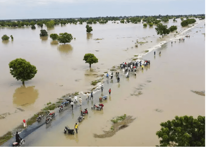
Across several parts of the Federal Capital Territory, heavy rainfall is repeatedly turning roads into waterways, submerging homes, disrupting businesses and leaving motorists stranded.
While intense rainfall is an immediate trigger, evidence increasingly points to a deeper problem: Abuja is losing the natural and built infrastructure that should absorb, channel and safely discharge stormwater.
Blocked drainage channels, construction around waterways, inadequate drainage capacity, indiscriminate waste disposal and the steady conversion of vegetation and open spaces into concrete surfaces are combining to increase the city’s vulnerability to flooding.
A recent study of Abuja’s drainage infrastructure found severe blockage across several chronically affected corridors, including the Galadima Interchange Slip Road, Apo–Dutse Road, Damagaza Road, Area 3 in Garki, Lokogoma and Lugbe. The study reported blockage levels ranging from 42 to 95 per cent and concluded that drainage deficiencies accounted for a substantial share of observed flood severity.
Read also:
- Cross River Provides Financial Support To Families Of Flood, Landslide Disaster Victims
- Residents Block Calabar–Itu Highway Over Flooding, Demand Probe of Road Project
- Fact Check: Is Lagos-Calabar Coastal Highway Mitigating Lekki Floods Or Adding Fuel to The Fire?
The problem is not confined to one district.
In Wuye, flooding after a heavy downpour in May caused serious traffic congestion along the road near Wuye International Market and the Family Worship Centre. Eyewitnesses blamed blocked drainage channels and described the flooding as a recurring problem whenever there is heavy rainfall.
For residents, the issue has become more than an inconvenience.
In Nyanya, resident Ibrahim Adamu said blocked drains had made flooding a recurring problem.
“Most of the drains are blocked with refuse. Once it rains heavily, water overflows into the roads and sometimes into people’s homes,” he said.
In Gwagwalada, Grace Oche called for authorities to act before the situation worsens.
“We don’t want a repeat of what happened last year when many houses were flooded. Government should act now by clearing all the drainage channels,” she said.
A Kubwa trader, Zainab Sani, pointed to another dimension of the problem —,public attitudes towards waste disposal.
“People throw refuse inside gutters, and when rain comes, it blocks everywhere. Both government and residents have roles to play,” she said.
But drainage blockage is only one part of Abuja’s flood problem.
In 2023, the Federal Capital Development Authority identified the constriction of waterways and inadequate hydraulic structures as major factors behind flooding in parts of Abuja. Officials specifically highlighted areas around Trademore Estate, Lokogoma and Efab Estate, while warning about development along water courses.
The situation has remained particularly concerning around Lugbe and Trademore.
The Federal Government previously identified recurring flooding along the River Pyakasa corridor as a major challenge, attributing the problem to a combination of unusual rainfall, urbanisation, undersized hydraulic structures and siltation of the river and drainage infrastructure.
A 2026 study focused on Lugbe found that 34 per cent of the area falls within moderate-to-high flood-hazard zones, with some severe locations recording flood depths of more than 1.5 metres. The study identified River Park Estate, Trademore Estate, the Voice of Nigeria axis and settlements around Lugbe Fruit Market among areas with significant exposure.
Residents of Mabushi have also experienced the consequences of living close to natural water channels.
In May, floodwater submerged the ground floor of a residential building on Anthony Ikem Street, behind Blue Cabana Hotel. The water reportedly reached window level, damaging household belongings, food items and important documents. Following the incident, the FCT Emergency Management Department advised residents living around waterways and flood-prone areas to relocate.
But Abuja’s flood crisis is not simply about what has been built over waterways. It is also about what has disappeared from the landscape.
Green areas, forests, grasslands and other natural surfaces act as part of the city’s stormwater management system by allowing rainfall to infiltrate the soil rather than immediately becoming surface runoff.
Research published in 2026 found that Abuja’s green-space ratio fell from 42.43 per cent in 1990 to 17.9 per cent in 2023, while green area available per person declined from 73 square metres to 22.68 square metres. The study linked the decline to urbanisation, land-use pressure, weak enforcement and other development pressures.
Another recent assessment of land-use change in the Federal Capital City found that built-up areas expanded dramatically while forest and grassland declined by more than 86 per cent. The research concluded that the expansion of impermeable surfaces increased runoff and intensified flood vulnerability.
This transformation is visible in the rapid development of districts that were once dominated by vegetation and undeveloped land.
As concrete replaces soil, rainwater has fewer places to go.
Roofs, paved roads, parking areas, concrete compounds and other impermeable surfaces prevent infiltration. Instead of soaking gradually into the ground, rainfall moves rapidly across these surfaces, placing additional pressure on drainage channels that may already be blocked, undersized or poorly maintained.
The Federal Capital Territory’s own officials have previously acknowledged the connection between development and flooding.
The FCDA has warned that some residents and developers mistakenly regard reserved green areas and waterways as available land, despite their designation for drainage, sewer lines and other infrastructure. The agency specifically linked encroachment on such reservations to flooding, particularly in parts of southern Abuja including Lokogoma.
More development produces more runoff. More runoff places greater pressure on drainage systems. Blocked or undersized drains slow the movement of water. Encroached waterways restrict natural channels. The disappearance of vegetation reduces opportunities for infiltration. And when intense rainfall arrives, water accumulates faster than the city can safely carry it away.
In Wuye, motorists have been trapped in flood-induced gridlock. In Mabushi, floodwater entered homes. In Nyanya, residents complain of water entering houses. In Gwagwalada and Kubwa, residents have called for urgent intervention. In Lugbe and Trademore, recurring flooding has become a long-standing concern.
The warning signs are therefore clear: Abuja’s flood problem cannot be solved simply by waiting for the rains to stop.
It requires sustained desilting of drainage channels, enforcement against dumping refuse in waterways, proper maintenance of existing drainage infrastructure, protection of natural water courses, stricter development control and the preservation and restoration of green infrastructure.
The Federal Emergency Management Department has also urged residents to avoid dumping refuse into drainage channels and to pay attention to flood warnings as the rainy season intensifies.
For residents already living with the consequences, the demand is straightforward: authorities must act before the next downpour turns another Abuja neighbourhood into an island.
And for a city originally designed around planned development and environmental balance, the bigger question is whether Abuja can continue to expand without destroying the natural systems that make the city resilient.